Miyerkules, Agosto 5, 2015
The Pacific Ring of Fire
Pacific Ring Of Fire
The Pacific Ring of Fire is an area in the Pacific Ocean where a large number of earthquakes and volcanic eruptions occur. In a 40,000 km horseshoe
shape, it is associated with a continuous series of oceanic
trenches, volcanic arcs,
and volcanic
belts or plate
movements. It has 452 volcanoes and is home to over 75% of the world's active
and dormant
volcanoes. The Ring of Fire
is sometimes called the circum-Pacific belt. About 90% of the world's earthquakes and 81% of the world's largest earthquakes
occur along the Ring of Fire. The next most seismically active region is the Alpide belt,
which extends from Java to the northern Atlantic
Ocean via the Himalayas and southern Europe. All but 3 of the
world's 25 largest volcanic eruptions of the last 11,700 years occurred at
volcanoes in the Ring of Fire. The countries that belongs to the Ring of Fire
are Chile, Mexico, United States, Antarctica,
Russia, Japan, Philippines, Japan, New Zealand, Papa New Guinea, Indonesia, Canada, Peru, Taiwan, and Guatemala. The Ring of Fire is the result of plate tectonics. Tectonic
plates are huge slabs of
the Earth’s crust, which fit together like pieces of a puzzle. The
plates are not fixed but are constantly moving atop a layer of solid and
molten rock called the mantle. Sometimes these plates collide, move apart, or slide next to each other. Most
tectonic activity in the Ring of Fire occurs in these geologically active zones.
A convergent plate
boundary is formed
by tectonic plates crashing into each other. Convergent boundaries are often subduction zones, where the heavier plate slips under the lighter
plate, creating a deep trench. This subduction changes the dense mantle
material into buoyant magma, which rises through the crust to the Earth’s
surface. Over millions of years, the rising magma creates a series of active
volcanoes known as a volcanic
arc. A divergent boundary is formed
by tectonic plates pulling apart from each other. Divergent boundaries are the
site of seafloor
spreading and rift valleys. Seafloor spreading is the process of magma
welling up in the rift as the old crust pulls itself in opposite directions.
Cold seawater cools the magma, creating new crust. The upward movement and
eventual cooling of this magma has created high ridges on the ocean floor over
millions of year.
Volcanoes are formed when magma from within the Earth's
upper mantle works its way to the surface. At the surface, it erupts to form
lava flows and ash deposits. Over time as the volcano continues to erupt, it
will get bigger and bigger. Scientists have categorized volcanoes into
three main categories: active, dormant, and extinct. An active volcano which has
recently erupted and there is a possibility that it may erupt soon. A dormant
volcano which has not erupted in a long time but there is a possibility it can
erupt in the future. An extinct volcano which has erupted thousands of years
ago and there’s no possibility of eruption.
Linggo, Hulyo 12, 2015
TOP 10 ACTIVE VOLCANOES IN THE
PHILIPPINES
1.)
Mount Mayon – Albay

Mount
Mayon, one of the most impressive Philippine landmarks, with an elevation of
2,462 meters is the most active volcano in the Philippines. Based on recorded
history of the country, this almost perfect cone volcano in Albay erupted at
least 50 times from 1616 up to present. One of the most remarkable and most
devastating eruptions of Mount Mayon was its eruption in 1766 that erased the
town of Cagsawa in the Philippine map. Only the bell tower of Cagsawa Church
remained above the new surface. Its last eruption was in January 2010.
2.)
Taal Volcano – Batangas

Taal
Volcano, situated within Taal Lake, has always been known to be one of the most
active volcanoes in the country and in fact tagged as the world’s most active
smallest volcano. This volcano located in Batangas province had erupted 33
times from 1572 to present. Its last eruption occurred in July 2009 and is
currently closely monitored for its abnormal activities which may result to
another eruption of this small but very active volcano. It has an elevation of
400 meters.
3.)
Mount Kanlaon – Negros Oriental

With
an elevation of 2.435 meters, one of the most active Philippine volcanoes is
Mount Kanlaon or Kanlaon Volcano. It had erupted at least 25 times already from
1886 up to present. It last major eruption happened in 1996 and had been
permanently monitored since then,
4.)
Mount Bulusan – Sorsogon

This
volcano with an elevation of 1,565 meters had erupted 15 times already from
1886 up to 2007. It has been closely monitored since its last eruption in 2007.
This active volcano is located in the so-called “little Switzerland of the
Philippines” – the province of Sorsogon.
5.)
Mount Makaturing – Lanao del Sur

Not
as popular as the Taal and Mayon volcanoes but Mount Makaturing, one of the
‘top ten highest mountains in the Philippines’, is also one of the most active
volcanoes in the country. It has an elevation of 1,940 meters and had erupted
10 times since 1882.
6. a) Musuan Volcano – Bukidnon

Another
not-so-famous volcano is Musuan Volcano located in the province of Bukidnon.
With an elevation of 646 meters only, it is one of the most active volcanoes in
the Philippines and had erupted 8 times in a span of 21 years from 1866 to
1887. Its last threatening activity of strong seismic swarm occurred in 1976
but has not erupted since then.
b)
Mount Ragang – Lanao del Sur

Mount
Ragang in Lanao del Sur, which is another tall mountain in the Philippines, is
another active volcano that had erupted 8 times and tied with Musuan Volcano as
the countries 6th most active volcano. Its last recorded eruption happened in
1916 or 94 years ago.
7. a)
Didicas Volcano – Cagayan
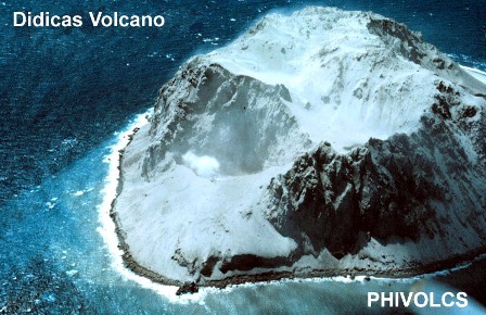
One
of the smallest and most active volcanoes in the Philippines is Dicicas Volcano
located in Cagayan province. With an elevation of 244 meters only it had
already erupted 7 times from 1773 up to 1990.
b)
Hibok-Hibok – Camiguin
Mount
Hibok-Hibok, one of the most popular volcanoes in the Philippines, had already
erupted 7 times since the recorded history of the Philippines. With an
elevation of 1,552 meters, this volcano’s first recorded eruption was in 1827
and the last was in 1952. It is tied with Didicas as the 7th most active
volcanoes in the Philippines.
8.)
Smith Volcano – Cagayan

Mount
Smith in Cagayan province with an elevation of 688 meters above sea level had
erupted 6 times already and the last known eruption of this active Philippine
volcano was recorded in 1924. This beautiful volcano is also known as Mount
Babuyan.
9. a)
Babuyan Claro – Cagayan

Babuyan
claro, an active volcano in Cagayan province, has an elevation of 1,080 meters
above sea level. It erupted in 1831, 1860, 1913 and its last eruption was in
1917.
b)
Mount Banahaw – Quezon

Tied
at 8th place as the most active volcanoes in the Philippines is Mount Banahaw
in Quezon province. It has an elevation of 2,158 meters and had erupted 4 times
since 1730 up to 1909. The mountain is considered 'sacred' by the residents of
the area.
10.
a) Dequey – Batanes

Dequey
Volcano, an underwater volcano, is located in the smallest province of the
Philippines – Batanes. With an elevation of -24 meters above sea level, it has
been known to have erupted 3 times - 1773, 1850 and 1854. It is considered as
Philippine most active undersea volcano.
b.)
Mount Parker – Cotabato

And
for the last spot as the Philippines most active volcanoes is Mount Parker, an
active volcano located in Cotabato. With an elevation of 1,824, its earliest
known recorded eruption occurred in 1800 BCE and its last major eruption was in
1641.
c.) Mount
Pinatubo

Mount
Pinatubo, which is located in the province of Zambales in Central Luzon, was
reawakened in 1991 producing the 2nd largest eruption in the 20th century. Two
milder eruptions followed in 1992 and 1993. Its last eruption prior to 1991 is
unknown. It has an elevation of 1,486 meters.
Mag-subscribe sa:
Mga Komento (Atom)